P
PicoSearch
Site Search by PicoSearch. Help
Home About Us News & Events East Anglian Waterways The Easterling North Walsham and Dilham - Updates North Walsham and Dilham - Then and Now Work Party Join & Donate Directors Links
And now have your say in the EAWA Forum
NEW! With General Forum for you to chat!

Aylsham Navigation

Also called the Upper Bure Navigation

Upper Bure from Norfolk Mills, with photos!

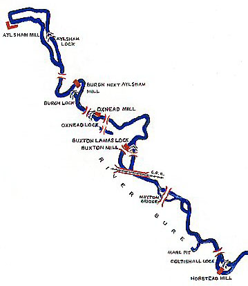
Running 9.5 miles with 5 locks using the course of the upper Bure River plus a mile of cut to Aylesham Basin.

The completion of the Bure navigation canal (Aylsham Navigation) in 1773 brought further wealth to the prosperous town.

"The Bure, which washes the foot of the town, was formerly only navigable from Yarmouth to Coltishall, (11 miles below Aylsham bridge by the water, and 7 by land;) but in 1773, an act was obtained for extending the navigation to Aylsham, for boats of 14 tons burthen, drawing two feet five inches water, which was completed after many difficulties and interruptions, in Oct., 1779, at a cost of upwards of £6000, including the cost of the basin and wharfs near the bridge, where much business is done in coal, corn, timber, &c."

January 1773 - Authorised by an Act of Parlament

January 1774 - Construction started.

January 1779 - Opened in October.

The final end for this scheme was the devastating flood of 26th August 1912.
The great flood destroyed all locks and the Aylsham Navigation was closed.

November 1928 - The navigation abandoned.

1974 - the Aylsham Canal basin was filled in.

The community project plans to commemorate the 100th anniversary of the closure of the Aylsham Navigation.

Websites - please look at aylsham-navigation.norfolkparishes.gov.uk
This is the new web site for Brampton and your comments would be very welcome.

The Aylsham Navigation according to IWA.
It is Waterways Under Restoration according to them!

The Project: Aylsham-Navigation.norfolkparishes.gov.uk/

Photos of a trip from Horstead Mill to Buxton. - "Song of the Paddle Forum"